Friday 20 April 2018

Heading through the mountains to Alájar in search of water!

We had 3 lovely days/nights in Aracena but as we needed water and to dispose of our chemical/grey waste it was time to move on.  Unfortunately, there are no Aires or campsites nearby that provide this so we had to drive north 45kms to Cumbres Mayor – the nearest Aire for facilities, that is on the edge of the town overlooking the castle and next to a helicopter landing pad. (N38.05937 W6.63784)
I guess when you are 800 metres, perched on a hill getting an ambulance in and out of the village and to a hospital is a tricky and lengthy operation, so a heli pad is a necessity.  One of the most precious commodities for us as a motorhomer is water. We have a 100 litre fresh water tank, that when full lasts about 4/5 days and we usually carry between 4-8 litres of bottled water as well.  Although we try to be sparing with water, the difference of knowing you have access to water is being able to have a long showers (4-5 minutes) or no access means a short one of 2 minutes water on/water off, and when you have been doing lots of walking you need nice long showers!
En route  to Cumbres Mayor, we stopped off Galaroza to do a short walk (10kms).
The walk took us to Castaño del Robledo – a small village high up in the mountains, where cats and dogs outnumber people.  It doesn’t have any shops but what do you know, it has 3 bars around a small plaza - Mel’s type of village!

Very old village in need of some roof repairs
You know it's a small place when the town hall doubles up as a bar and post office!

Walking along the old bridleway, through the oak and chestnut forests
So, stocked up with water, all waste dumped and Sonny, the motorhome given a spring clean, we left Cumbres Mayor and headed south east 44kms to Alájar.  It is the next village west of Aracena and one of the prettiest in the Sierra. (N37.87423 W6.66948).  It is overlooked by the towering Peña de Arias Montano – a rocky outcrop with a church and belfry and we are wild camping beneath it.
Our wild camping spot on the edge of  Alájar
Peña de Arias Montano

From the top you get a stunning view of the village, its fields of olive trees and the surrounding mountains
On the 7th/8th September the religious pilgrimage – Reina de los Angeles (Queen of Angels) is celebrated - a deeply rooted tradition in the village.  We did two walks from here.  Our longest to date a 16km walk took us through 3 villages, climbing high again to the village of Castaño del Robledo, that we had walked through the other day.
Castaño del Robledo
It doesn’t matter how many walks you do from these little villages/hamlets it is inevitable that you will visit some of them more than once as they are linked by centuries old criss-cross paths and bridleways, and are quite well marked out with painted wooden posts.

A great sign, which basically translates to ‘take only photos and leave only your footprints
Sitting in a burnt out oak tree. Much of the forest disappeared in the 18th and 19th centuries when they were burnt for charcoal.
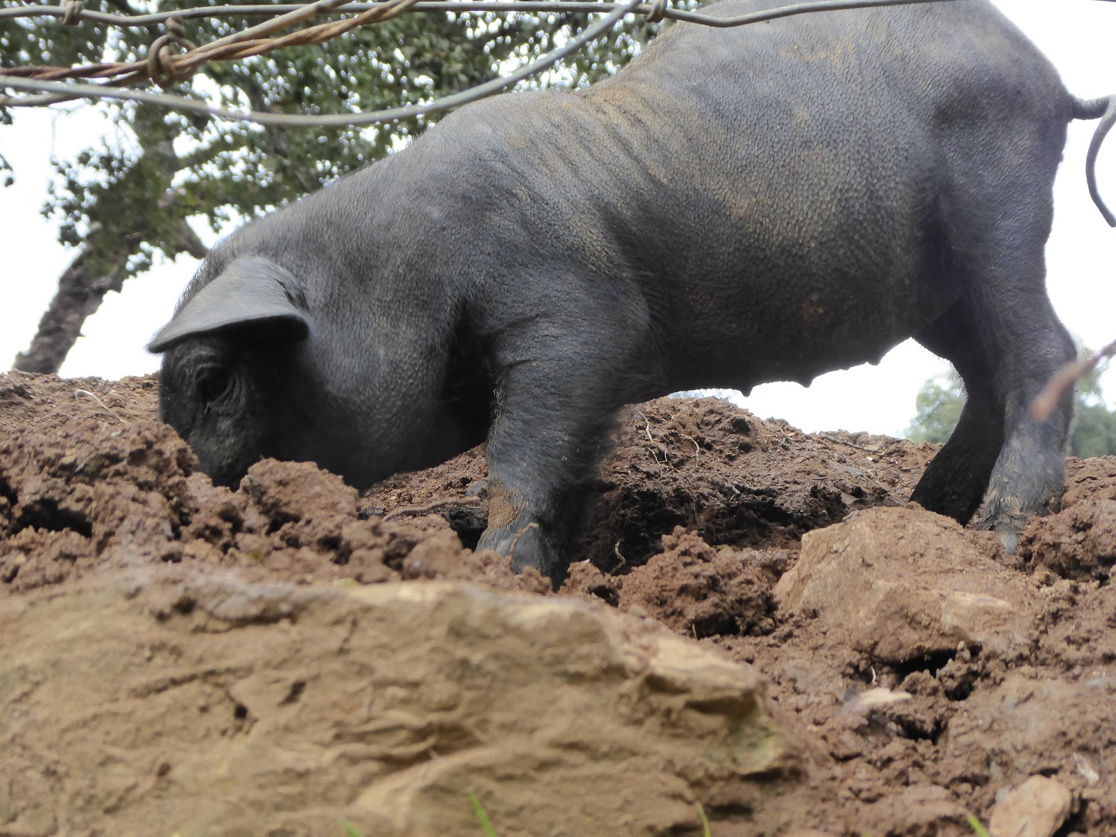
About 1km outside of Alájar, is a remote hamlet with a bohemian collection of yurts, teepes and caravans hidden away in the forest ,which is home to a long-established hippie group.  They appeared to have everything they needed - gas and water, and it all looked fairly clean.  They were friendly people as well and we met a few of them when they came down into Alájar for a drink.
Walk 2 was a short circuit of 10kms.  We were up and out fairly early, as we knew once the sun was up it was going to reach 28°C so we didn’t want to be walking in it much past lunch time. The walk took us along stretches of the old cobbled mule paths linking the abandoned hamlet of Los Madroñeros, when everybody left in the 19th century. However, when we passed through we saw an elderly man and women who appeared to have set up home there, plus a couple of cars.  Not sure how they get in and out as there are no roads, only cobbles and dirt tracks!
The hamlet's little square, with its only tree left - a mulberry?
The houses in Alájar huddle around a tiny square and its narrow, cobbled streets radiate outwards from here.  We sat here enjoying a drink and tapas after our walk, soaking up the sun.
From here we moved on to the village of Almonaster, 10km west of Alájar to do….. yes you guessed it another walk!  It was only 9.5 kms but a steep climb to 810km to Sierra San Cristóbal.  The walk took us through a couple of hamlets, where we saw no movement of life whatsoever!  Walking through these old forests, you never know what your going to find though - things all made out of scrap metal in this farmers garden!


The castle and mosque on the hill at Almonaster
Built in the 10th century, it is one of the oldest mosques in the region.


There wasn’t anywhere to stop for the night in Almonaster, so we headed 50kms south to Valverde del Camino (N37.58114 W6.75162), and like the Aire at Cumbres Mayor, it was on the edge of the town with free water and chemical waste facilities.  The only thing we knew about the place is that it’s famous for the manufacturing of Spanish vaquero-style leather riding boots.
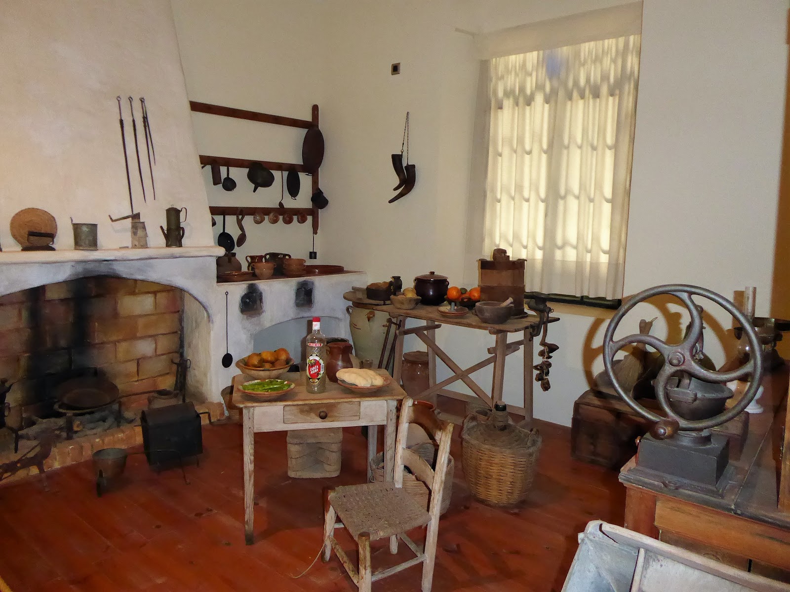
It wasn’t until we walked into the town that just behind the Aire is an English museum – La Casa Dirección.  Ironically, nobody could speak English but we managed to communicate and got to walk around it all for free.  All the information was in Spanish and was difficult for us to translate but there were quite a few artefacts from the railway, workshops of leather footwear, wood and metal rooms, clothing and a kitchen full of implements that were used in those days.
It was built in 1912 as a residence of the Director of the Alkali United Company.  During the late 19th century many British companies set up in this area in search mainly of copper.   As a result, a small British community settled in Valverde del Camino to help construct and operate the mining railway and to manage several mines, including Rio Tinto which is nearby.  The British passed on their knowledge of traditional production and the town became the first Andalucián producer of footwear, with renowned furniture industry and other crafts that in the rest of the country have disappeared. The house has been restored but the English architecture retained and the gardens have been converted into an outdoor amphitheatre and railway park.


There are a few walks you can do from here and of course we had to do one before leaving! The mining past of Valverde del Camino has left the route of the old mining railway that runs through here and all the way down to the coast of Huelva.  We managed to find a route of about 10km that took us along the old railway line, which forms part of the 'Via Verde' (railway lines that have been converted into walking and cycling routes).  There are some lovely flowers and plants that grow along the old railway line.

So, where do we move on to from here? Mmm food for thought or maybe not as life in Sonny, the motorhome is not about serious consideration but going where the mood takes us!

Sally x

Sunday 15 April 2018

High up in the mountains of Aracena

Sonny, the motorhome is enjoying life back on the road, after 6 days parked up in Punta Umbría whilst we visited Adam and Melissa again.
We have headed north 120kms into the Sierra de Aracena Natural Park.  There aren’t any Aires in Aracena so we are parked in a car park at the edge of the town (N37.88906 W6.56984) and have been joined by some Dutch, Germans, Spanish, French and Portuguese motorhomes over the last 3 days.  It is nice and quiet apart from Saturday morning, when the market traders set up their stalls nearby from 8am onwards!
View of the castle from Sonny's front door!
The mountain road took us passed Rio Tinto, the third richest mining company in the world producing mainly copper, iron ore, silver and coal.  It’s like a giant crater, a few kilometres wide and one giant blot on the landscape.
The giant opencast mines of Rio Tinto
The town is dominated by a hilltop ruined castle, built in the 13th century on the base of a Moorish fortress and a church that was converted from a mosque. 

The bull ring
On the edge of the town is an old washing area. There used to be an old water spring here, which came from the lakes of the Maravillas Caves and was converted to a washhouse in 1926.
The square next to it has ceramic painted tiles depicting different areas of the caves and a couple of sculptures dedicated to the washing ladies.
Plaza San Pedro
Aracena is famous for its spectacular limestone caves – the Gruta de Las Maravillas (the Cave of Marvels).  Opened in 1914, it's a 1km circular tour of the underground streams and caverns - well worth a visit!
The Museo del Jamon (Ham museum), where you can learn about the life of the Iberia pigs and the production of the Iberian Ham.

Narrow, steep cobbled street of Aracena
This is our third visit to Aracena, and we have done all the tourist visits - the castle, caves and ham museum.  This time the visit was all about the walking!
Setting off on our walk we got caught up in the Huelva Extreme cycling race.  The cyclists (about 1500) travel a distance of nearly 200kms, starting at Higuera de la sierra, (neighbouring village to Aracena), they cycle cross country through all the little villages and finish on the coast at Mazagón (near Huelva).
Watching the last of the cyclists go by.
The circular walk took us west of Aracena down country lanes, cobbled donkey trails, through olive groves and cork oaks and encounters with Iberian pigs to the pretty medieval-looking village of Linares de la Sierra.  The town only has a population of 300 inhabitants and even though it was a Saturday it was very quiet.
A unique feature of the village are the mosaic areas in front of many of the old village houses, made out of light and dark cobbled stones. 

Mosaic 'carpet' outside the houses in Linares

Plaza de Tores - sitting in the grandstand of the old bullring, which is now the main village square
Enjoying a cold beer in the Plaza de Toros. - thirsty work all this walking!
Pretty little butterfly that stayed still just long enough for me to 'snap' it!
Little black pig sniffing out those acorns
Our second walk the next day took us east of Aracena, to the little village of Corteconcepción.  Walking through the olive groves we spotted a goat high up in the branches.  The last time we saw this was in Morocco, where they climb the branches of Argan Trees to eat the fruits.
You can just make out the goat at the top of the olive tree, whilst one appears to be keeping guard below!

Cork Oaks

Prized Iberian pigs grubbing for acorns
Mirador Los Portales at Corteconcepción, overlooking the Aracena reservoir
Communal washing area, a typical feature in all these little villages
There isn't a lot to see in this little village, so after a quick walk around and a drink in the plaza it was time to head back to Aracena where we caught some pigs having a siesta!
Even the pigs have a siesta in Spain!
We move on tomorrow, further into the national park.

Sally x

Sunday 8 April 2018

From the kite surfers paradise of Tarifa, to the sherry loving Jerez

Leaving Gibraltar we went west 50kms around the coast to Tarifa. Just 11km across the Straits of Gibraltar at its narrowest point, Punta de Tarifa is the southernmost tip of the Iberian Peninsula and continental Europe, and marks the geographical division between the Atlantic Ocean (to the west) and Mediterranean Sea (to the east).
Looking towards Punta de Tarifa, with views  across the Rif mountains of Africa across the water - Mel is searching for them through the haze!
It is a very windy corner of Spain and is the world's most popular destination for wind sports.  Walking across the causeway to the point we struggled to stay on our feet, as we got battered with the wind, sea spray and sand.
As far as you can walk out on the tip.   The island  (Isla de las Palomas) at the end is blocked off by a rusty iron gate with restricted access.
At the end of the Punta de Tarifa is Isla de las Palomas, once a military base. You can peer through rusty old gates and make out some of the military remains and a lighthouse.
Down at the beach where all the kite surfers congregate.
This Little fishing town was the first point of the Morrish invasion of Southern Spain in AD711,   It was lovely strolling around the narrow cobbled streets of this ancient old town, but unfortunately in parts it looked like it was lacking a bit of love and financial investment.
Castle of Guzman El Bueno (originally built as an alcaxar in 960AD to protect Tarifa against raids from Africa) and statue of King Sancho IV, who reconquered Tarifa from the Moors in 1292

Castillo de Santa Catalina built as an observation tower in 1931 with its Gothic/Islamic style arches and balconies -  with its WWII bunkers below.
Leaving Tarifa we headed north for Jerez- the sherry capital of Andalucía.
About 8kms west from Tarifa is a popular area for bird watchers, especially this time of year when flocks of birds return to Europe from Africa.  We noticed lots of motorhomers wildcamping around this area, for us though it was too windy for us to want to stay. Winds batter this area for nearly 300 days of the year – the Levante (easterly wind from Africa) and the Poniente (westerly wind from the Atlantic). 
The roadside most of the way from Tarifa to Jerez was lined with wind turbines as far as the eye can see, due to its unique wind conditions on this coastline.
The Aire (N36.71329 W6.10948) is about 5km from the town, next to a motorhome dealers.  We stopped here last year, and it’s the nearest place to stay overnight.  For €15 it has everything (electric, water, showers/toilets), there is also a well stocked motorhome shop and laundry. Plus, you even got a free sherry on arrival - perfet!   It was then time for a little bit of tapas 'Harrison style' in the motorhome before a walk into Jerez.  Scraping  the barrel a bit I know, but it was all we had in!
The Alcázar - an 11th-12th century fortress - a good spot to chill and for views across the city.
The cathedral, which dates back to 1264.  It’s €5 to go in, we went in last year so gave it a miss this time but it is well worth it to see all the paintings and artifacts.
Outside Jerez Cathedral

The ornate San Miguel church
Another worthwhile visit is to the Bodegas Tio Pepe, which we did last year. The tour lasts about 1 ½ hours and you hop on and off a train to take you round all the cellars. You can then do some sherry tasting and tapas.  For more info see my last year’s blog: Jerez de La Fronteria – Sherry Land! [link]
Statue of Tio Pepe
 Weather vane that can be seen from the Alcazar, which according the Guinness Book of Records is the biggest in the world
Plaza del Mamelon, with its bronzed horse statue
Time for a quick beer before getting the bus back to the Aire.
From Jerez it was back to Punta Umbría to drop off Adam’s Morrisons Gibraltar shopping!  We plan to stop with him and Melissa for a few days before heading back up into the mountains of Aracena.

Sally x